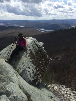
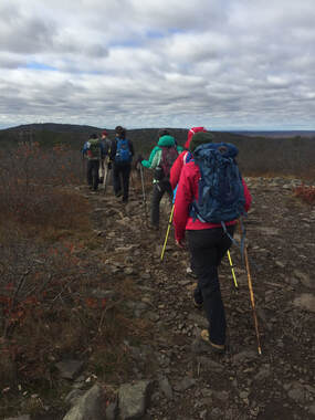
At this point I’m done with all that and looking for a taste of spring—or at least some snow free ground. If you’re of the same mind, the good news is that there are some really great mountain ranges to hike which melt out a lot sooner than the high peaks (by virtue of being further south, lower in elevation, or because they are covered primarily with deciduous trees). Here is a list of my favorite relatively snow-free mountain ranges to hike in the Northeast United States during the spring season. Not only will these mountain ranges melt out a lot sooner, they’re scenic, tough, rocky, and rewarding hikes that are worth visiting any time of the year. I briefly list and describe them below but will be following up with an in-depth profile on each range through April and May. (Note that camping options during the spring may be limited until Memorial Day weekend when campgrounds tend to open up, but other forms of lodging are likely to have vacancies and reduced rates in the spring). 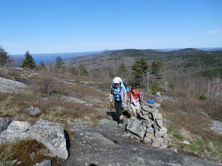 Hiking the Belknap Range in spring. 1: THE BELKNAP RANGE Where: The Lakes Region, New Hampshire; about 1 hour south of the White Mountains and 100 miles northwest of Boston. What: Sixteen (more or less, depending on how you count them) summits, many with dramatic views of Lake Winnepesaukie and more open ledge than you can shake a stick at. Over 60 miles of trail: short, moderate and long loops, and long-distance traverses are possible. There is even a hiking patch challenge associated with completing a traverse of the Belknaps. Info: AMC Southern New Hampshire Guide and maps. Online Belknap Range map. 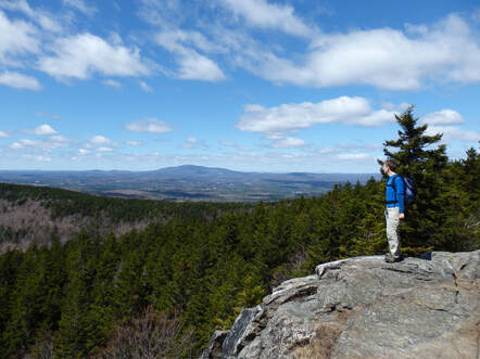 The Wapack Range's North Pack Monadnock in spring 2: THE WAPACK RANGE Where: South-central New Hampshire and adjacent Massachusetts, about an hour northwest of Boston. What: The 22-mile Wapack Trail traverses this linear mountain range over ten slabby peaks which poke up from dense coniferous and deciduous forests; there are excellent views over the surrounding rural countryside from the summits. Hikers tend to favor either a manageable 10-ish mile partial traverse or the full, difficult long-distance traverse, but there are also short and moderate loop options especially at the north and south ends of the range. Info: Wapack Range Guide and map, AMC Southern New Hampshire Guide and maps.
The terrain is surprisingly diverse with open ledges, rocky tarns, waterfalls, historic ruins, wetlands, a startling knife-edge arete, and talus slopes. Info: AMC Southern New Hampshire Guide and maps. Pisgah State Forest map, Wantastiquet to Monadnock Trail maps.  The view from Maiden Cliff in Maine's Camden Hills 4: THE CAMDEN HILLS Where: Maine seacoast, 1 hour and 40 minutes north of Portland. What: Rugged, rocky highlands with many open ledges and precipitous cliffs overlooking the Atlantic Ocean and inland lakes. Hikes are clustered around the Camden Hills State Park (6 peaks) and nearby along the Hills section of the Georges Highland Path (4 peaks), and there are several other satellite peaks to do as well. Short, moderate and long loops and traverses are possible; hiking all 13 peaks in the Hills region would add up to a very challenging experience. Info: Camden Hiking & Biking Map. AMC Maine Hiking Guide, Maine Trail Finder
Hikers often favor single traverses (depending on route, 7-9mi, circa 1,500ft eg) or double traverses (out-and-back) but the extensive, dense network of trails make for nearly unlimited short and long possibilities. Info: Blue Hills Reservation Map; AMC Massachusetts Trail Guide and maps. 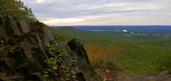 View from the cliffs of the Holyoke Range 6: THE HOLYOKE RANGE Where: The Pioneer Valley of Massachusetts, near the University of Massachusetts in Amherst; 45 minutes north of Hartford, CT. What: This unique, deeply fissured line of semi-open volcanic cliffs plunge up to 1,000 feet into the surrounding lowlands of the Connecticut River Valley. The Range offers a long, rollercoaster-tough traverse (about 14mi, 3,600eg), shorter segment traverses, and varied loop options. The New England National Scenic Trail traverses the crest of the range. Info: AMC Massachusetts Trail Guide and maps, Skinner/Mt. Holyoke Range State Park maps.
Short and long traverses, moderate and extended loops, and overnight backcountry treks are all possible. The Appalachian Trail traverses the east branch of the Range and the South Taconic Trail the west branch of the Range, with many shorter connecting trails between. Info: AMC Massachusetts Trail Guide and maps, NY-NJ Trail Conference South Taconic Trail Map. 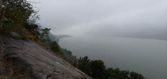 View of the Hudson River from the precipitous Breakneck Ridge in the Hudson Highlands 8: THE HUDSON HIGHLANDS Where: 1.0 to 1.5 hours north of New York City What: Over 100 miles of trails crisscross the mountains and hills of the Hudson Highlands on both sides of the Hudson River through several state parks, wildlife preserves, and non-profit conservation lands extending from the New Jersey border to the Connecticut border. Same-day or multi-day overnight backcountry trips and varied same-day loops are all possible. The long-distance Appalachian Trail and the Long Path traverse the Highlands. Some of the most dramatic and rugged terrain in the Northeast can be found where the Hudson River has gouged through the Highlands near Storm King and Bear Mountain (ex., the infamous Breakneck Ridge). Info: NY-NJ Trail Conference maps; ATC Appalachian New York-New Jersey Guide. Happy snowless spring hiking!--Paul-William
1 Comment
If you are thinking of hiking high ground during spring but have limited experience doing so, this article is for you.
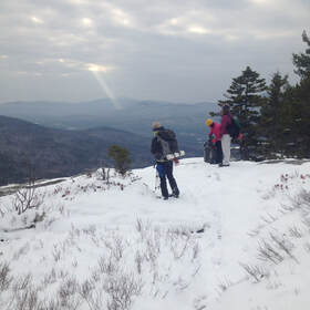
spring is the only season where one might experience the entire range of conditions during a single hike-- sheer ice, hard snow, deep soft snow, bare ground and ledge, and uncompromising mud. Hiking safely in this season requires careful planning and forethought. Spring season hiking can be divided into two sub-seasons: “Mud-season” (running from the end of March through Memorial Day) and “late spring” (Memorial Day through mid-June) where conditions start resembling what most people think of as spring. This is a generalization, of course—latitude, elevation, aspect (whether one is on the sunny vs the cooler side of the mountain) as well as the local winter snow load (which varies year-to-year and place-to-place) will really determine where in this spring continuum one stands. Mud Season is particularly problematic— hiking during this season has a disproportionately damaging impact to trails (see my article on Mud Season hiking). It was once the case (circa 25 years ago) that spring season hiking in the high peaks was the province of skiers trying to grab a few final runs before melt-off, and a few diehard masochistic hikers who didn't know when to quit. These days, amidst the popularity of hiking lists fueled by social media, and standing squarely in the heyday of light traction devices (Microspikes, et.al), spring hiking has become much more accessible and desirable. This inevitably means that someone who isn’t ready for the mercurial nature of spring conditions in the high peaks might end up having an uncomfortable, embarrassing, or hurtful experience. People do die with avoidable frequency in the mountains during the spring—hypothermia, frostbite, slips on ice, falling ice, and avalanches are just as cruel in the spring as they are in winter. 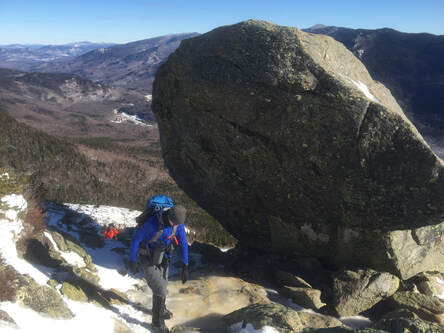 Glen Boulder in spring Based on a skimming of questions in various hiking forums, here is a Q&A to help those just starting out with spring hiking in the high peaks understand what they are getting into:
Q: Which mountains in the Northeast are known to have difficult spring hiking conditions? A: Just about any mountain can be more challenging during the time between full winter snow cover and melt-off. The higher the peak, the longer winter-ish conditions will persist into the spring season. Look for particularly challenging conditions in the Adirondacks, Green Mountains, White Mountains, the highlands of northern Maine (from Grafton Notch northeast to Katahdin), and (to a lesser extent) the Catskills. Peaks above 3,000 feet anywhere in the northeast, and even lower elevation peaks in the higher latitudes should likewise be treated with the same respect through May. Q: What kind of weather should I expect in the high peaks during spring? A: Anything goes in the spring in the high peaks. You could have a full-on blizzard with fierce winds, hypothermia-inducing freezing rain, or sunny “beach weather.” Night-time temperatures may plunge significantly. Before you go, check weather reports frequently for changing summit conditions (not base conditions) and take your forecast with sobriety. Q: What kind of trail conditions should I expect in the high peaks during spring? A: Again, just about anything goes. If there was a recent spring blizzard, you could have deep unbroken snow in higher elevations. The norm tends to be a lot of ice, patches of bare ground and ledge, deep pockets and fields of drift snow (deeper and more persistent in shady areas and north slopes), and lots of mud. Snow consistency can range from concrete in the morning and evening to mashed-potatoes by mid-day. If your trail has wet brook crossings (no bridge), expect anything from wet feet to drowning torrents (drowning deaths in spring flows in the mountains aren’t rare enough). Avalanche and crushing ice-fall conditions may persist in the steeper open ravines, cirques, and on slides (as late as early July on Mount Washington). You can check trip reports at trailsnh.com to get a better sense of ground conditions, but you should carefully scrutinize trail-guide descriptions and maps as well. Q: What kind of gear should I bring for a high peaks trip in the spring? A: Plan on taking your full winter gear unless you have a recent trip report and a good weather forecast that suggests leaving something behind (for instance, a well broken out trail may not necessitate snowshoes). Always carry traction; consider full crampons for ice. Bring all of your winter clothing and safety gear but be prepared to dress down to base layers on a warm day. The cardinal rule is: when in any doubt, bring all of the gear. Q: I don’t have winter gear (snowshoes, traction, insulated boots, winter layers). Are there any high peaks I can safely do in the spring? A: It depends. On many high peaks you might not have full melt out until June, sometimes later. That said, you may be successful and safe hiking one of the smaller of the high peaks with south-facing approaches later in the spring if conditions are favorable. Again, check trip and weather reports. Lack of evidence should make you assume that the worst conditions prevail! Q: I am just starting out hiking the high peaks of the northeast. Is spring a good time to start? A: It can be the most discouraging time to start. To the extent that your inexperience could get you hurt or color your first big hike in an unpleasant light, shoot for summer or early fall. Until then, it may be wise to either hike with an experienced 4-season high peaks hiker who can show you the ropes, or consider smaller mountains (it is no secret some of us “big peak hikers” actually prefer to hike smaller mountains in the spring because conditions there are more enjoyable). Q: What about camping in the spring in the high peaks? A: Unless you are camping at low elevations, assume you’re camping in winter conditions and bring the appropriate gear (including a winter sleep system—don’t skimp on sleeping bag and sleeping pad thickness). If you haven’t camped before, spring (and winter) are difficult seasons to become accustomed to it. Q: Are there other things I need to be concerned about when hiking the high peaks in the spring? A: Yes. At lower elevations, black flies start emerging in May and can be pestilential enough to make a person want to jump off a cliff--bring bug repellant. Lack of leaf cover in early spring and light reflecting off snow can mean unrelenting sunlight on your corpse-pale winterized skin-- bring sunscreen, sunglasses, and a good hat with a visor. Black bears emerging from hibernation in the spring are ravenous from fasting all winter. If you are camping plan to secure your food in a bear cannister or with a bear proof hang bag system (cannisters are specifically required in parts of the Adirondacks). Don’t leave packs and food unattended. Happy Spring Hiking! --Paul-William *I realize this term is often applied to a certain part of the Adirondacks; I use it more generally in this case.
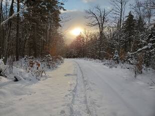
Vermont’s Green Mountain Club, which manages the famous 272-mile Long Trail (the first long distance hiking trail in the United States, which inspired the Appalachian Trail and other long distance trails), routinely closes the Long Trail and other high-elevation side trails during Mud Season. The closure lasts from late March through Memorial Day even though actual “Mud Season” conditions are not necessarily uniform throughout the trail system. During the closure, hikers are strongly encouraged to pursue other activities or hike lower elevation terrain where the ground has had a chance to dry out sooner. Generally speaking, most hikers in Vermont respect this—some out of a sense of personal responsibility, some falling into line through raw peer pressure. But Mud Season isn't unique to Vermont--it's an issue throughout the Northeast (for instance NY and NH) and other northerly latitudes. Changing how you hike in Mud Season is important. Trails are particularly vulnerable to destruction when the soil is saturated and 24-hour day/night spring freeze-thaw cycles are taking place. Wet trails churned up by a lot of boot traffic and frost heaves will erode quickly during the next heavy spring rain or warm-day melt-off, which means that trail maintainers (perpetually overworked, underfunded, underpaid, and with a backlog of priority trail work already on their slate), have to work a lot harder to shore up degraded trails. Hiking during Mud Season can also cause significant ecological damage—this is particularly true with regard to the fragile, endangered alpine plant communities above treeline. 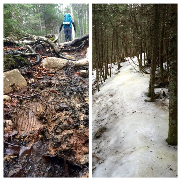 Spring conditions on the Crawford Path: muddy trail and ice "monorail." [Photo: Iva Blazina Vukelja] Too, Mud Season conditions influence hikers to use the trails in ways that exacerbate trail entropy. Spring ice “monorails” (caused by hikers compacting snow into very hard ice over the course of the winter hiking season) melt slower than the surrounding snowpack, keeping trail soils damp longer, and creating unpleasant slippery obstacles. Monorails also increase the speed of runoff and channel water flow along the sides of trails, gullying them. To avoid slipping on the monorail (especially on the downhill) and to avoid stepping in the muddy areas that have melted out around the monorail, some hikers (too many!) will walk off trail, which causes a widening of the trail course called “trail braiding.” Braided trails move the footway away from the true trail and whatever erosion control measures (water bars, steps, etc.) were built into it. This results in more erosion and can make it harder for hikers to identify the correct trail course during snow-off conditions, exacerbating the problem.  Above treeline during mud season, following monorail melt-off. Notice the footbed of the trail is wetter than the surrounding terrain. The foremost hiker is hiking off the trail and in the fragile alpine area to avoid the mud. {Photo: Iva Blazina Vukelja] The best way to avoid damaging trails in mud season is to refrain from hiking them until they have sufficiently dried out, i.e. hike elsewhere, at lower elevations, or further south, or engage in other activities altogether. Whether a trail is sufficiently dried out can be subjective and hard to assess if you don’t have experience with trail maintenance (and that’s why the Green Mountain Club has a general “closure” season). In places other than Vermont, one might consider a general rule of thumb: when the snowpack surrounding the trail is more than 40% melted out over any course of 500 feet in length; when there is a lot of lingering monorail with melted-out bare earth surrounding it; when the mud on the trail is ankle-deep or deeper for extended stretches; when you are finding yourself frequently walking around the trail to avoid ice and mud instead of on it—you’re probably hiking in “Mud Season.” 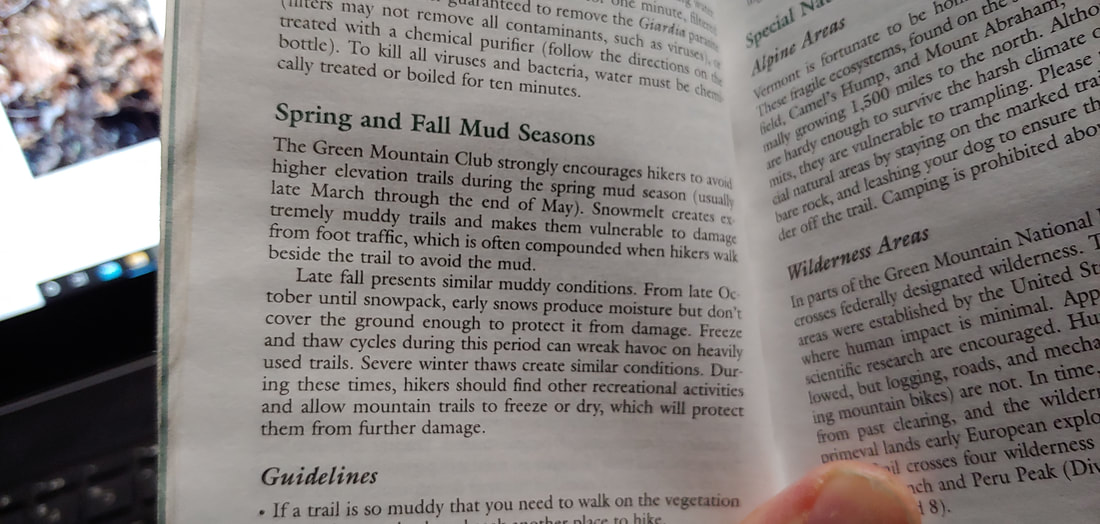 GMC's Long Trail Guide has a section dedicated to Mud Season etiquette. If you are determined to hike in the early spring (perhaps you’re Gridding and are reluctant to give up the month of April), there are some things you can do to reduce your impact:
See you in the spring! --Paul-William
“Slog” is a very apt term for what is a sadistic exercise in mental endurance—especially at the end-of-day whilst physically exhausted, when distance-marking visual cues have evaporated in dusk. For those "slogged" When will it end? isn’t an uncommon fixation. Beyond the madness-inducing tedium, the slogs can also be physically painful. I have a longstanding knee injury; hiking flat terrain for a long stretch is harder on my knee than ups or downs because I’m locking my knee in a relatively rigid position and inviting repetitive-use fatigue instead of flexing out the kinks as would naturally happen on irregular mountain terrain. Doing this in snowshoes or boots over hardpan monorail can be even more grueling. Although my handicap isn’t universal, I’ve spoken to more than a few people, both knee and hip-impaired, who have the same issue with the slogs.
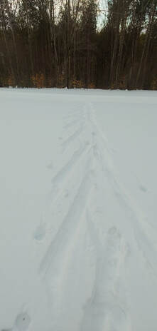
. . .and yes, it counts towards your winter list dibs. As long as snow conditions are favorable, you can shave off a little time, a lot of fatigue, and add a little extra fun into your adventure. I use this method almost exclusively for the long flat winter approaches, and I weep with pity as I pass those poor wretches limping out in snowshoes. How it helps:
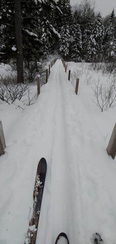
What approaches it's good for: Out-and-back hikes with long, relatively mild terrain: Lincoln Woods Trail, Zealand Road, Sawyer River Road, Gale River Road, etc. In Maine, it can be used to get to some of the “Sixpack” Hundred Highest Peaks, Mount Abraham via the snowed-in Firewarden’s Road, and to the base of Katahdin or the Brothers in Baxter State Park (lugging a sled into the park behind your skis, which is surprisingly easy). If you’re a fair skier you can even get a little further up some of the milder but narrower trail sections beyond the roads mentioned above, and if you’re a skilled skier you can throw in some steeper trails and open woods glade runs if conditions are right. When to do it: When the snow is good—deep enough to cover hard obstacles and exposed drainage channels. Ideally, the snow is broken out and not too icy or crusty; temperatures are below freezing. If snow is deep and unbroken, and you have company, you can take turns breaking it out with about the same effort or less as you’d expend with snowshoes, creating nice runs for yourself on your return trip. It is easier to ski out on a once-broken ski trail than it is to snowshoe out on a once-broken snowshoe track because the track of skis is continuous, flat, and uninterrupted, not choppy like snowshoes tracks. Avoid icy conditions and unbroken snow with thick crusts. Avoid trails with frequent or long steeps (unless you are a good skier), lots of narrow twists and ledge-hops, and open water crossings.
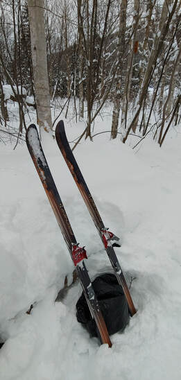
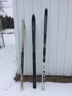
Gear you’ll need: Skis: Your best bet are medium to wide Nordic skis--many recent models are “shaped” (the width of the skis changes from the front to the ski to the middle, and again to the rear of the ski) which offers more turning capacity; look for outer measurements in the high 60cm range to the 112cm range. Generally speaking: the wider the ski, the more floatation, stability, and turning ability. You can use narrower Nordic skis with equal success if the terrain is milder, groomed, or fairly beaten out by other skiers (Lincoln Woods Trail and Zealand Road are often well broken out by skiers) or if you’re a good skier. The length of your ski will depend upon the characteristics of your ski brand and style vs. your weight— check the manufacturer’s guidelines. Other ski characteristics: you’ll want a steel edge to cut through rougher snow patches, and a climbing pattern on the bottom of the ski for ascending (which saves you the curse of wax-on, wax-off, repeat--visualize the Karate Kid--with different kinds of waxes for different temperatures and conditions).
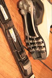
Boots: First and foremost, make sure that your boots are compatible with your bindings! The hardware on ski boots is engineered to only work with a specific kind of binding. Second, you’ll want something light and fairly flexible for the long slogs; go with synthetic fabric or leather (not hard plastic). Third, make sure that you buy boots that have adequate winter insulation. Although you can hike in Nordic boots, you may not find them quite as comfortable on steep mountain terrain as hiking boots, but you can experiment—if you don’t mind hiking in them, you can save yourself some weight by not carrying hiking boots on your trip. The ducktail toe on 3-Pin boots might interfere with snowshoe and traction bindings, however.  Nordic boots built for use with 75 mm 3-pin bindings. Note the three holes and duckbill at the front sole of the boot. Poles: Ski poles or adjustable trekking poles with a snow basket attachment will both work fine. A wider basket is preferable for deeper, unbroken or minimally broken snow but a small trekking basket may work just as well on packed or groomed surfaces. I keep a wide basket on my poles all winter long.  Collapsible Black Diamond ski/trekking pole with wide snow basket. Gear you might want: Climbing skins (a fabric that is stretched across the bottom of the ski for extra traction) can be useful in places where the terrain is rolling with frequent short steep sections, and the snow is firm and slick. You can use the skins to help you climb and to slow your descent. A small plastic ski scraper can come in handy if you happen to slush your skis through running water on colder days. Several ski gear manufacturers make lightweight packable models (ex. Swix and Dakine); while most are intended to scrape wax off skis, they will work well for ice, too (if you have a climbing traction pattern on your skis, be sure to scrape front to back). If you plan on carrying your gear over some steep terrain for moderate stretches, take along a ski strap so that you can tie your skis together and throw them over your shoulder. Most skis come with a ski strap when you purchase them. Gear you probably won’t need: Unless a lot of your travel is going to be downhill on long steeps, avoid gear that is intended specifically for downhill. Traditional downhill (lift-service) alpine skiing gear is useless on the slogs. "Backcountry" alpine gear (AT bindings, NTN bindings, 75mm 3-pin bindings with fixed, non-removable cables, etc.) is intended primarily for climbing up then skiing down. Although you can manage flat terrain with them, they won’t offer you the speed and ease of use on long slogs that Nordic gear provides. If you’re inclined to do a lot of “hike-up, ski down” activity (for example the Moosilauke Carriage Road and the Hale Firewarden’s Trail) these are probably the kind of setups you’ll want to look at. But that kind backcountry skiing takes skill and practice and is beyond the scope of this article. Another type of ski that probably won’t net you much in the way of energy savings on the slogs are short, “hybrid” skis" (ex. Altai Hoks or Black Diamond Glidite) that strap to hiking boots. These skis can be great fun for narrow and/or steeper downhill terrain, particularly in powdery snow and/or on bushwhacks and narrow, winding paths, and for climbing moderately steep irregular terrain. On the long flats and mild rolling terrain, they will perform more like snowshoes than skis on average (better than snowshoes on moderate downhills).
That’s all folks—this article is intended as a primer; there’s more you can learn about skis and skiing. Hope to see you cheerfully beating the slogs in skis! This article was inspired by a recent conversation on the Random Group of Hikers FB page. |
TOPICS
All
Humor (The Parsnip)
|


 RSS Feed