|
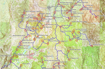
Details What follows is a list of the highest summits in Southern New England, 108 summits in Massachusetts and 9 in Connecticut. I originally wanted a list of the 100 highest summits but added in a few additional peaks for a nice even cutoff of 1,700 feet. From this list once can derive a shorter “Southern New England 2000 List” (a moderately digestible 56 summits), stick with the entire “Southern New England 1700+ List” or create some other sub-list variation. A simple version of THE LIST is shown at the bottom of this page, embedded. For more. . . CalTopo online interactive map of THE LIST KML (GIS) of THE LIST Details List DISCLAIMERS: I created this list primarily out of statistical and geographic curiosity. It is not a “hiking” list per se, although it does provide information that would be useful to hikers. Although many of the peaks can be hiked, some are on private land on which hikers may or may not be welcome, and a few of them are near houses or other structures. Any “peak bagging” inspired by this list would take into consideration private property rights and would exclude peaks that are posted against trespass and/or are located near houses, yards, and other private structures. In all cases, when hiking, please be aware of where you are, respect “No Trespassing” signs and private dwellings/ yards/ quarries/ active logging operations/ windmills/ farmland or other areas your presence may not be welcome, whether posted or not. Trespassing on private land without permission, or behaving poorly on any land, is a sure way to ruin things for everyone. See the resources section below for ways to reach private landowners for hiking permission. Th extended PDF version of this list contains a notes section which documents some potential trail conditions and some potential routes, mileage estimates derived by remote GIS, and other factors not necessarily verified by recent physical visitation; actual, on-the-ground conditions may vary and be subject to the capriciousness of nature, human neglect and error, and the limitations of interpreting geophysical data remotely. Summits without trails may present unusual challenges such as dense brush, cliffs, swamps, and other navigation hazards, usually suitable for hiking only by those with advanced bushwhacking skills. I will not post tracks for these peaks; that would ruin the fun. Hiking and bushwhacking in the mountains of southern New England is a somewhat different experience than it is in northern New England. Deciduous trees tend to dominate. Snowfall is less deep and the snow season is shorter (relative to elevation). Most of the summits on this list have substantially shorter approaches (not a few of them less than 1 mile in length) than what is common up north. There is no krummholz in southern New England, but there are often laurel thickets which are just as (if not more) unyielding than krummholz. The local term for the phenomenon is "laurel hell"--need I say more. While Lyme disease carrying ticks are extremely rare on the high peaks of northern New England, they are a common hazard in southern New England. You'll find them in spring, early summer, and late fall right up to snowfall (and occasionally in thaws). Land ownership is less consolidated, less public, more subdivided, more developed, and more likely to be posted against trespass in the south. Advice aside, in no case is this material intended to be a hiking guide. The information provided here is for statistical and geographic curiosity only. Use it at your own risk. How This List Was Derived: I created this list by using the CalTopo online GIS mapping tool, ARCGIS, USGS maps, OpenStreet data, online resources and blogs, and past and present editions of popular hiking guides. Accurate elevation was determined per USGS-map elevation notes. USGS numeric summit and col elevations (elevation notes are rare for cols) were accepted where provided. In the absence of a numeric elevation, elevation was estimated by the method of adding half the contour interval to the highest contour line. Summit elevation derived this way is denoted by an asterisk (*) on the list next to the peak name. I did not rely on GIS/GPS elevation derived estimates because they lack sufficient precision and accuracy—until professional-grade measuring equipment proves otherwise, the method described above is the last word for this list. Prominence was determined by finding the elevation of the highest col between the peak and a higher neighbor along the common watershed divide, with a minimum of 200 feet in descent as the standard. Peaks lacking prominence above neighboring higher summits in New York and Vermont were likewise disqualified. Where there are two peaks of equal height but insufficient col between them, both summits are included in this list until such day that one is determined to be slightly higher (there are two instances: Camp Rest vs. Dorman; Canaan South vs. Old Man McMullen). Because the Berkshires are more properly a dissected highland plateau peppered with erosion-resistant hills (similar to the Catskills and Alleghenies), determining prominence proved to be particularly challenging—the nearest prominence-bearing col for some of these peaks were many miles away in a sea of peaks of relatively the same overall height. Although I was thorough, my current list may still contain some errors—missing peaks or miscalculated prominence. Corrections/Suggestions: Note that I will not be considering hand-held GIS field data as suitable proof for making corrections to this list—in my experience, hand-held non-professional-grade equipment lacks sufficient accuracy. Please contact me if you find a USGS map-verifiable error or have a question. To assist in understanding how prominence was derived, I have provided GIS of the peaks with lines showing the connecting watershed divides. Consulting these data in Caltopo over a USGS base map may help shed light on the logic of this list. Nomenclature: When available, I used summit names shown on USGS maps. Lacking designated names, I got creative, using other sources of data, or adopting names for peaks based on nearby features. These are indicated in italics in the spreadsheet. I rejected the urge to blindly rely on names assigned by Open Street Map data (OSM; open source data commonly used by non-Google source GPS apps) where there was no corresponding name shown on the USGS map. OSM has the habit of naming peaks for the nearest named geographical feature, regardless of what it is, with some truly awkward results. I chose to be more thoughtful than that. Mountain Ranges & Divides: All of the summits on this list belong to three distinct major sub-ranges of the Appalachians: the Taconics, the Berkshire-Green Mountains, and easterly of the Vermont line, various southerly foothills of the collective White Mountains-Maine Mountain ranges, of which only two peaks in southern New England rise above 1700 feet: Mount Wachusett and Mount Watatic. The Berkshires of Massachusetts and Green Mountains of Vermont are one geologic mountain-building event arbitrarily divided by relatively fleeting political boundaries; the Berkshires are essentially the smaller foothills of the Greens. The Taconic Mountains are often culturally conflated with the Berkshires but are geologically and visually different in character and origin—and older. The peaks of the Taconics in southern New England all derive their ultimate prominence from Mt. Greylock, the Massachusetts state highpoint. Greylock in turn is captured by Glastonbury Mountain in Vermont, by way of the Hoosic-Housatonic watershed divide in Lanesborough, Massachusetts, passing first through the Hoosac Range and collecting about 8/10ths of the Berkshires along the way, with the exception of those peaks north of the Deerfield River which descend from Jillson Hill just over the line in Whitingham, Vermont. Ultimately, all of the peaks in the Berkshires and Taconics meet in prominence at Stratton Mountain in Vermont. Lonely Wachusett and Watatic derive their prominence from Holt Peak on Temple Mountain in the Wapack Range of New Hampshire. Tying all of the peaks on this list together would require some gymnastics along the NH-Quebec boundary, but all would ultimately meet at Mt. Washington in New Hampshire. Special Note on the Taconic Crest and Taconic Skyline Trails: The Taconic Crest Trail (TCT) and Taconic Skyline Trail (TST) were once two distinct trails each on its own distinct ridge: the TCT followed the ridge along the MA/NY boundary from Perry’s Peak just south of Route 20 to central Pownal, Vermont. The Taconic Skyline trail followed the parallel ridge to the east, beginning in Pittsfield State Forest and through the north peak of Brodie Mountain (with plans to extend it to Greylock that were sadly never realized). Because confusion is well loved by people hiking in the woods, the TCT now officially begins in Pittsfield State Forest and has largely absorbed the southern route of the former TST, thence it continues through the intervening valley and over the its original route on the MA/NY border (and, depending on what resource you are consulting, perhaps only as far as Highway 2 south of the VT border, beyond which it is no longer “official”). The TST, on the other hand, is now entirely within Pittsfield State Forest and is an ATV-designated trail supposedly paralleling the current Taconic Crest Trail, and there is no longer an “official” trail over Widow White’s Peak and Brodie Mountain. In this document I refer to the two new routes of the TST/TCT and also the “old” route of the Taconic Skyline. Don’t say I didn’t warn you. Recommended Resources: Massachusetts’ OLIVER online GIS mapping tool (http://maps.massgis.state.ma.us/map_ol/oliver.php), has land-ownership ID capabilities, along with lots of base map and overlay layers to play with. It’s much more clunky and slow than CalTopo and lacks good trail data, but with it, it’s now quite easy to find public land boundaries and learn the name and address of private landowners—with which to write to them to ask permission to hike on their land (or one can approach things the old fashioned way and inquire with town tax clerks. Either way, please write thoughtfully and respect whatever response you get without a whimper or bad smell). The CalTopo (https://caltopo.com/map) online mapping tool is extremely useful in finding trails and making routes which can be uploaded to GPS or just gloated over on a laptop. A number of useful base maps can be brought to bear, including USGS, USFS, aerial imagery, Google, etc., and can be overlain with the latest trail, elevation, and other data, including the excellent non-proprietary OpenStreetMap data which contains constantly updated hiking and bike trail information from around the world. For field GPS I recommend an Android or Apple platform phone with a Gaia GPS app. The premium version of this app ($36/year in 2019) provides a license to a variety of base maps including a very useful private lands layer which shows property boundaries (very useful for hiking peaks on this list) but the lesser subscriptions tiers are also worthwhile. Phones are just as accurate as dedicated hand-held non-professional (survey) grade GPS units these days. To date, Android platform phones have better long term battery function than Apple phones, especially in cold weather. Portable, external phone backup batteries are cheap, light, and can be bought at department or electronic stores. The Appalachian Mountain Club prints the popular Massachusetts Hiking Guide series, of which there have been many editions since the 1960s (some of these were useful in compiling this list). Though less biblical than its more comprehensive cousins written for hiking in Maine and New Hampshire, it is still the standard in printed hiking guides for the state, but it does not include maps for all of the trails it details. In Connecticut, the Connecticut Forests and Parks Association prints the useful Connecticut Walks book which also has been through several editions and does include maps for all of the trails it describes. Both are worthwhile purchases. P. Gagnon, 2018 |
|
|
Elevation |
Town |
Lat |
Long |
|
|
Greylock, Mount |
3491 |
Adams |
42.6370 |
-73.1661 |
|
Crum Hill |
2841 |
Monroe |
42.7107 |
-73.0195 |
|
Blackpoll Mountain* |
2790 |
Florida |
42.7196 |
-73.0399 |
|
Bakke Mountain, Upper |
2770 |
Florida |
42.7358 |
-73.0401 |
|
Spruce Mountain |
2730 |
Monroe |
42.7051 |
-73.0055 |
|
Prospect, Mount |
2690 |
Williamstown |
42.6624 |
-73.1825 |
|
Misery Mountain |
2683 |
Williamstown |
42.6554 |
-73.2980 |
|
Beoadic Mountain |
2621 |
Hancock |
42.5829 |
-73.2744 |
|
Everett, Mount |
2608 |
Mount Washington |
42.1020 |
-73.4326 |
|
Spruce Hill, North |
2596 |
North Adams |
42.6765 |
-73.0674 |
|
Rounds Rock* |
2590 |
Cheshire |
42.5903 |
-73.1993 |
|
Stony Ledge |
2579 |
Williamstown |
42.6433 |
-73.1941 |
|
Berlin Mountain, South |
2547 |
Williamstown |
42.6739 |
-73.2842 |
|
Ragged Mountain* |
2530 |
Adams |
42.6451 |
-73.1466 |
|
Bordon Mountain* |
2510 |
Savoy |
42.6012 |
-73.0274 |
|
Brodie Mountain, North Peak |
2454 |
New Ashford |
42.6243 |
-73.2614 |
|
Frissell, Mount |
2454 |
Mount Washington |
42.0513 |
-73.4819 |
|
Burnett Hill* |
2430 |
North Adams |
42.6469 |
-73.0738 |
|
Widow White's Peak |
2428 |
Lanesboro |
42.5475 |
-73.2697 |
|
Ashley, Mount |
2390 |
Mount Washington |
42.0617 |
-73.4749 |
|
Race, Mount |
2365 |
Mount Washington |
42.0823 |
-73.4319 |
|
Bear Mountain |
2323 |
Salisbury, CT |
42.0447 |
-73.4548 |
|
Honwee Mountain |
2313 |
Lanesboro |
42.5103 |
-73.3063 |
|
Poppy Mountain |
2311 |
Hancock |
42.5238 |
-73.3099 |
|
Judges Hill |
2297 |
Windsor |
42.5189 |
-73.0317 |
|
Weston Mountain |
2270 |
Dalton |
42.5141 |
-73.1170 |
|
Finerty Peak |
2263 |
Washington |
42.3203 |
-73.1760 |
|
Alander Mountain |
2240 |
Mount Washington |
42.0878 |
-73.5046 |
|
Haskell Hill |
2234 |
Peru |
42.4098 |
-73.0383 |
|
Pine Mountain |
2220 |
Hancock |
42.4942 |
-73.3199 |
|
Walling Mountain |
2220 |
Beckett |
42.3106 |
-73.1571 |
|
Gridley Mountain |
2211 |
Salisbury, CT |
42.0394 |
-73.4671 |
|
North Mountain |
2211 |
Lanesboro |
42.5288 |
-73.1560 |
|
Watson Mountain, North* |
2175 |
Washington |
42.3529 |
-73.1659 |
|
Smith Mountain |
2170 |
Hancock |
42.4826 |
-73.3350 |
|
Watson Mountain, South |
2170 |
Washington |
42.3452 |
-73.1608 |
|
Cole Mountain |
2133 |
Cheshire |
42.5944 |
-73.1623 |
|
West Mountain |
2125 |
Plainfield |
42.5327 |
-72.9582 |
|
Yokun Seat |
2124 |
Lenox |
42.4009 |
-73.3063 |
|
Wilcox, Mount |
2112 |
Monterey |
42.2192 |
-73.2664 |
|
Adams Mountain* |
2110 |
Rowe |
42.6894 |
-72.8846 |
|
Washington Mountain* |
2105 |
Washington |
42.3747 |
-73.1637 |
|
Hawks Mountain, Upper* |
2090 |
Hawley |
42.6200 |
-72.9551 |
|
Plantain, Mount |
2088 |
Mount Washington |
42.0643 |
-73.4534 |
|
Tully Mountain |
2085 |
Hinsdale |
42.4404 |
-73.1602 |
|
Bryant Mountain |
2080 |
Cummington |
42.4748 |
-72.9684 |
|
Perry Peak |
2070 |
Richmond |
42.4209 |
-73.3799 |
|
Harvey Mountain |
2065 |
West Stockbridge |
42.3128 |
-73.4251 |
|
Warner Hill |
2050 |
Hinsdale |
42.4174 |
-73.1519 |
|
Yankee Mountain* |
2050 |
Rowe |
42.7206 |
-72.9182 |
|
Darby, Mount* |
2030 |
Mount Washington |
42.1321 |
-73.4574 |
|
Parker Hill* |
2030 |
Hawley |
42.5728 |
-72.8986 |
|
Stony Ledge, West |
2030 |
Williamstown |
42.6460 |
-73.2144 |
|
Sugarloaf |
2030 |
New Ashford |
42.5926 |
-73.2215 |
|
Knowles Hill |
2011 |
Worthington |
42.4297 |
-72.9643 |
|
Wachusett Mountain |
2006 |
Princeton |
42.4889 |
-71.8866 |
|
Wadsworth Hill |
1999 |
Beckett |
42.2887 |
-73.0977 |
|
Beals Hill |
1995 |
Hawley |
42.5503 |
-72.9291 |
|
Leonhardt Peak |
1991 |
Becket |
42.3100 |
-73.1141 |
|
Wildcat Mountain* |
1975 |
Great Barrington |
42.2167 |
-73.2922 |
|
Bradford Mountain |
1962 |
Canaan, CT |
41.9893 |
-73.2946 |
|
Mott Mountain |
1962 |
Peru |
42.3899 |
-73.0756 |
|
Camp Rest |
1956 |
Tyringham |
42.2585 |
-73.1723 |
|
Dorman Mountain |
1956 |
Otis |
42.2437 |
-73.1604 |
|
Cranberry Mountain* |
1950 |
Hancock |
42.4425 |
-73.3658 |
|
Pulpit Peak* |
1950 |
Rowe |
42.7066 |
-72.9406 |
|
McLennon Mountain* |
1945 |
Otis |
42.2214 |
-73.1568 |
|
Tom Ball Mountain |
1933 |
West Stockbridge |
42.2693 |
-73.4003 |
|
Todd Mountain* |
1930 |
Rowe |
42.6949 |
-72.8747 |
|
Holy Mount |
1927 |
Hancock |
42.4512 |
-73.3533 |
|
Ethel, Mount |
1925 |
Mount Washington |
42.1250 |
-73.4798 |
|
Savage Hill |
1924 |
Lanesboro |
42.5366 |
-73.2122 |
|
Prospect Hill |
1919 |
Mount Washington |
42.1427 |
-73.4875 |
|
Clark Mountain |
1916 |
Savoy |
42.6467 |
-72.9654 |
|
Fray, Mount* |
1905 |
Egremont |
42.1571 |
-73.4814 |
|
Warner Hill* |
1890 |
Plainfield |
42.5299 |
-72.9128 |
|
Cemetery Hill * |
1875 |
Heath |
42.6805 |
-72.8139 |
|
Pocumtuck Mountain |
1872 |
Claremont |
42.6514 |
-72.7743 |
|
Morley Hill* |
1865 |
Sandisfield |
42.1663 |
-73.1644 |
|
Chestnut Hill* |
1855 |
Monterey |
42.1721 |
-73.1711 |
|
Dry Hill, East* |
1855 |
New Marlborough |
42.1456 |
-73.2246 |
|
Lenox Mountain, South |
1853 |
Lenox |
42.3654 |
-73.3153 |
|
Shaker Mountain |
1845 |
Hancock |
42.4459 |
-73.3369 |
|
Watatic Mountain |
1832 |
Ashburnham |
42.6967 |
-71.8925 |
|
Two Top Mountain* |
1830 |
Hawley |
42.5811 |
-72.9326 |
|
Stock [Stockbridge] Mountain |
1828 |
West Stockbridge |
42.3244 |
-73.3528 |
|
Hunger Mountain* |
1825 |
Monterey |
42.1856 |
-73.1823 |
|
Livermore Peak* |
1825 |
Monterey |
42.1951 |
-73.2787 |
|
Abbey Hill* |
1815 |
Sandisfield |
42.1392 |
-73.1584 |
|
Carley Hill* |
1815 |
Heath |
42.7051 |
-72.8525 |
|
East Mountain* |
1805 |
Great Barrington |
42.1635 |
-73.3237 |
|
Town Mountain* |
1795 |
Sandisfield |
42.1434 |
-73.1360 |
|
Round Top Hill |
1794 |
Chester |
42.2550 |
-72.9864 |
|
Pettibone Ridge |
1786 |
Cheshire |
42.5493 |
-73.1900 |
|
Noppet, The |
1775 |
Lanesboro |
42.5543 |
-73.2471 |
|
Negus Mountain |
1773 |
Rowe |
42.6646 |
-72.9457 |
|
Crissey Ridge* |
1770 |
Norfolk, CT |
41.9460 |
-73.2372 |
|
Maple Hill |
1766 |
West Stockbridge |
42.3110 |
-73.3902 |
|
Bald Mountain* |
1765 |
Norfolk, CT |
42.0272 |
-73.2167 |
|
Cross Place Mountain |
1765 |
Washington |
42.3612 |
-73.0827 |
|
Fife Peak* |
1765 |
Rowe |
42.6832 |
-72.9658 |
|
King Corner Peak |
1763 |
Hawley |
42.5705 |
-72.9416 |
|
Seventy-Six Hill |
1762 |
Ashfield |
42.5011 |
-72.8059 |
|
Goose, North |
1753 |
Lee |
42.2919 |
-73.1890 |
|
Cole Mountain, North |
1752 |
Adams |
42.6052 |
-73.1489 |
|
Monument Mountain |
1750 |
Stockbridge |
42.2586 |
-73.3499 |
|
Tunnel Peak* |
1750 |
Rowe |
42.6742 |
-72.9809 |
|
Filley Mountain, South |
1748 |
Sandisfield |
42.1674 |
-73.1117 |
|
Landers Peak |
1747 |
Lee |
42.3098 |
-73.2142 |
|
Canaan Mountain, South* |
1745 |
Canaan |
41.9438 |
-73.2690 |
|
Old Man McMullen Mountain* |
1745 |
Canaan, CT |
41.9523 |
-73.2615 |
|
Barry Hill, West |
1735 |
New Marlborough |
42.0473 |
-73.1825 |
|
Stone Man Mountain |
1732 |
Canaan, CT |
41.9573 |
-73.2825 |
|
Goose, South |
1724 |
Tyringham |
42.2693 |
-73.2102 |
|
Dodds Mountain* |
1715 |
Sandisfield |
42.0676 |
-73.1182 |
|
Wangum Mountain* |
1715 |
Canaan, CT |
41.9705 |
-73.2575 |
|
Holcomb Hill |
1713 |
Chester |
42.3246 |
-72.9574 |