Apparently an AllTrails user posted a “hike” that described the herd path to Mendon Peak as “a moderately trafficked out and back trail” and the description and route were being utilized by people who did not know it was really a moderately trafficked herd path a.k.a former bushwhack turned into trail by the weight of pop-culture peaking bagging (and do compare “path” and “trail” in the dictionary when you have a moment). "Shame on whoever runs that site," the commentary began, “They are leading unprepared people into the wilderness with false information.” And then the usual pile-on about AllTrails began: “I would never, ever use AllTrails”, “garbage,” “wrong,” “I am glad you are spreading the word about AllTrails,” and (from the obligatory purist’s point of view) “Following someone else’s digital breadcrumbs goes against the spirit of the NEHH list regardless of how accurate your app might be.” 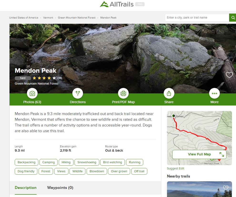 The offending AllTrails Mendon Peak description. Just about anytime someone brings up AllTrails in hiking social media discourse, the semi-commercial (both free and $30/year Pro options) app/website gets more than its fair share of hate. To be fair to the haters, as a source of accurate hiking information, AllTrails (existing in both website and smartphone app form) has its flaws. AllTrails hiking information is crowdsourced: hikers report their hikes to AllTrails along with GPS tracks produced by the AllTrails app, and AllTrails then publishes them—with minimal review and no pro vetting. The introduction of each hike starts with a stock language format blurb intro into which variables (some of them multiple choice) are filled in by the person doing the posting. For instance: "Mount Agamenticus via Ring Trail is a 1.7 mile heavily trafficked loop trail located near Cape Neddick, Maine that features beautiful wild flowers and is rated moderate. The trail offers a number of activity options and is best used from April until October. . . " Next there’s a GPS generated map (with an underlying stock OSM data layer, also a crowdsource product), a personalized hike description (which often gets overlooked), a weather forecast bar, then a crowdsource review section where others can rate and comment on the hike and their experiences with it. The net result is very akin to what you get with other crowdsource information streams (Wikipedia!): from very accurate and detailed data written by reliable hikers, right through mediocre intel from well-intentioned dilletantes (usually offering too much or too little information), down to occasional gnarly misinformation on the shitstick end of the bell curve. The running commentary and feedback offer the same spectrum of quality and utility. 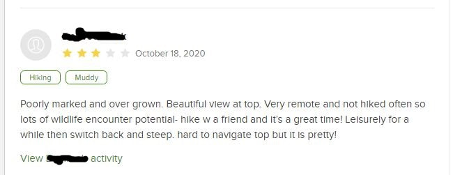 An AllTrails user leaves a comment on the Mendon Peak hike (username blotted out for privacy). Bad AllTrails intel includes bushwhacks and herd paths passed off as actual designated trails; trails on private property being advertised as public trails; the misnaming of trails, summits, and other geographic features; and lousy hike descriptions. The really bad stuff tends to not stick around forever—eventually it gets too many negative reviews or complaints and is pulled out, and even if it isn’t you can usually suss it out by reading the reviews. AllTrails also has formal processes for removing inappropriate or misleading trail intel. That said, a lot of crap does make its way through, and it sticks around long enough to piss off the “serious hikers” out there. The concerns aren’t without legitimacy: people will get lost or hurt, private property will be invaded (angering the landowners and ruining what might have been longstanding sanctioned local use), formerly quiet destinations will suddenly become more crowded. On the other hand, there’s a lot of griping and sniping that seems full of its own latent dysfunctionality: big-brotherism (you’ll get hurt if you don’t hike the way I hike), authoritative prerogative (these, not those, are the only correct sources of hiking information), hiking elitism (you either hike it this way or you’re not a legitimate hiker), and xenophobia/ nimbyism (I don’t want people ‘from away’ hiking on ‘my’ turf). Mostly, though, the criticism seems to originate in a misunderstanding of what AllTrails is. If you can handle throwing out the bathwater without dumping the baby, the app does have a certain unique utility. 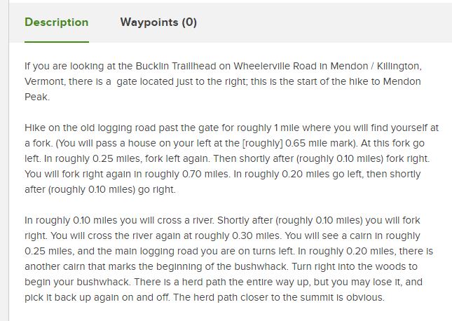 The individual who posted the Mendon Peak hike actually did describe it as a bushwhack--but you have to scroll down to see the non-stock description. People just don't scroll these days. What is the utility of AllTrails?
 AllTrails locating my lat/long and suggesting a range of nearby hikes for different interests. Additional categories followed. Using AllTrails is a bit of an adventure, for sure: it’s like venturing into a strange place without a map or reliable guide and having to ask the locals or weirdo riffraff explorers how to get from point A to point B. Some of them know what they’re talking about, and some don’t. Some can draw you a really good map on a napkin, and some will hand you a crap map that looks like a cartographer drafted it up. The more obscure the destination, the less numerous and helpful these people are going to be and the more uncertain your experience will be. You have to gather that intel and then use your own wits to make good decisions about where to go, how to go, and whose intel to trust. . .if you have no wits perhaps you’ll discover some through it. Think about that and let it sink in a moment: You have to gather that intel and then use your own wits to make good decisions about where to go, how to go, and whose intel to trust. The criticisms of using uncertain data of your choice to support your individual sense of adventure feel a little hollow, even controlling, when thought of in that light. Not being able to tell the difference between good and poor trail intel may say more about your own lack of hiking experience or your intolerance for uncertainty than it says about the value of the information itself.
There is also a special-flower kind of turf hypocrisy that plays out in knee-jerk social media criticisms of AllTrails. In comparing relative samples of advice and information supplied by members of Facebook hiking groups vs. crowdsource hikes posted on AllTrails, I don’t see a significant difference in good intel vs. bad intel (I prepped for this by reviewing a sampling of 30 high-response-volume Facebook posts and 30 random hikes posted on AllTrails, to arrive at nominal statistical legitimacy). So, if Facebook hiking forums are themselves crowdsource mosh pits (I dare you to disagree on that point—no disrespect to the hard-working moderators) why is it OK to be a member and participant there whilst shaming the consumption of AllTrails? Perhaps the commercial nature of AllTrails offends against the backdrop of its unvettedness? But AllTrails does donate 1 percent of its profits specifically to trail charities while (last time I checked) Facebook just enriches Mark Zuckerburg (does Zuck donate to trail charities? I have no idea). If it is not the commercialism of AllTrails that is odiferous, then is it that one can exude more control and authoritativeness in the context of a social media hiking forum among one’s known peers—vs. the authority-levelling peanut’s gallery of an AllTrails hike comment board? If it is not commercialism or the unavailability of ego-steroids, just what is it that is so hateful about AllTrails?
If you wanted to find out where to hike or how to hike, you either asked someone, read about it in a book you bought or borrowed, joined a formal hiking group (like the AMC, GMC, or ADK), or learned the hard way (guilty—my first White Mountains hike was Huntington Ravine, in a denim jacket emblazoned with a Jethro Tull album cover). You were fortunate if you were accidentally exposed to hiking—fitness consciousness was only just becoming a thing, and “getting back to nature” was still the province of hippies. If you were really serious and geeky about it (as was I), you spent hours pouring over topographic maps imagining what peaks were good places to hike and which ones would be duds. The thing is, we are really doing those same things these days, we’re just doing them a lot faster, often sharing in real-time and parsing data in much larger quantities. People still solicit advice from other hikers (now on social media and apps like AllTrails). People still give good advice and bad advice. People still read curated information, and curated information is still distributed and consumed in large quantities (AMC guides are distributed by Amazon and sell well pretty well there). People still participate in group hikes (witness the proliferation of Meetup). People still learn the hard way (by picking the lowest hanging source of information, lacing up a pair of shoes, and making a go of it). All of these methods are legitimate sources of learning how to hike, and, to some extent, unless we’re either extremely risk-adverse or extremely counter-dependent, we’ll use all of them at some point (even if we don’t admit it or are unaware we’re doing it). The kicker is that there are a heck of a lot more of us doing it. It’s crowded and hard to find a parking spot—and that rubbing of elbows constantly chafes on a subconscious level. If the number of fools in any given population is consistent across time (and why wouldn’t it be) that means that there are more fools on the trails now vs. 30 years ago but not more in proportion to the whole (you can test this theory by going back and looking at hiking accident reports from previous decades—trust me, we don’t have the market cornered on idiocy here in the 21st century). And it shows—fools do tend to make bigger headlines. They tend to trigger “serious hikers” more than ticks, blisters, or crotch-chaffing. Fools tend to leave bigger messes, and those messes are more obvious and impactful in the linear world of trails. Fools are more likely to need rescue. Fools take up space in parking lots, space on trails, space in campsites. They invade your space, waste your time, ruin your hiking zen, blast music while they hike, ask asinine questions, take selfies doing stupid things, and give you a big thumbs up while they “crush it.” And yet the sun shines on them equally, and the public open space is dedicated no less to them than to the trail-wise among us.
My supporting of hiking clubs and hiking groups, my pursuit of hiking lists and the creation of more lists, my peakbagging, my FKT, my adventure tourism, my nature loving, my tales of bears, my posting of hiking pictures with big thumbs up, my “crushing it”, my pole canopies, my support for the hiking gear industry (a lot of gear I can honestly hike without and not die), my support for making that gear into a fashion statement (and transforming the filthy exertion of hiking into a cool kid’s activity). My looking and sounding cool, wise, and authoritative on hiking forums and among other hikers. If hiking weren't a thing, AllTrails would wither on the vine. AllTrails exists because hiking is a popular thing, and hiking is a popular thing in part because I exist and call myself a hiker. The failings of AllTrails don't exist in a vacuum and aren't the real source of the hiking angst that wells up from my Freudian hiker-id-shadow when I bump into crappy hiking intel and behavior. I am. You are. We all are. --Paul-William Full disclosure: As a person who collects maps and hiking guide books as if they’re religious relicts, and is an admitted hiking geek and walking encyclopedia on hiking in the northeast United States and parts of Canada, I routinely use AllTrails as another source of hiking intelligence. Sometimes that intel is useful, sometimes it isn’t, but I’m glad to have it as a resource and will continue to unashamedly make high use of it, just as I make high use of the curated data. One doesn’t throw away a trove of data because one piece of it is proven inaccurate—that would be just as illogical as trusting all data unquestioningly.
2 Comments
Michael Blair
6/23/2021 08:31:30 am
Dilettante and shitstick in the same paragraph. Well done.
Brian C Aust
7/12/2022 01:32:48 pm
You asked: "if Facebook hiking forums are themselves crowdsource mosh pits (I dare you to disagree on that point—no disrespect to the hard-working moderators) why is it OK to be a member and participant there whilst shaming the consumption of AllTrails?" My answer, as someone who's worked for the GMC, AMC and now VT State Parks is simply this: No one is going to be following Facebook on their phone while navigating a given route, but lots of people definitely are looking at AllTrails while they're hiking. The thing is, people now want to rely on this free app that, as you note, contains information *and disinformation* that is crowdsourced by random people, whereas trail managers populate their analog tyvek maps, guidebooks, and now the digital resource TrailFinder.org with information that they themselves generated whenever in their history the trails were built. We can argue semantics all the live long day, but when it comes right down to it, I want to know the exact place I'm going to and the exact routes (assuming they exist) that will take me there as designated by those who either built the trails or took the time to map the herd paths (like the Adirondack Mtn Club's tyvek map shows). AllTrails might as well just be called SomeTrails (MostOfTheTime) because of how many times I have personally witnessed lost hikers - in my park, in the Presidential Range, or wherever - and how many times people have reported their AllTrails routes to be erroneous, plus how many dangerous situations have arisen leading to rescues of people who thought they were saving a few scheckels by relying on a crowdsourced guessing game of a navigation app rather than buying a paper map. All those maps make for a great scrapbook after a few decades of collecting as it turns out! Leave a Reply. |
TOPICS
All
Humor (The Parsnip)
|
 RSS Feed